|
|
Augmented reality and image recognition as tools for eParticipation6. January 2010 – 13:14 by Bengt Feil |

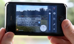
Augmented reality on iPhone (Wikipedia)
Locations and places play in very important role in many eParticipation processes. As a matter of fact eParticipation in urban planning is one of the most successful areas eParticipation to day. In the case of participation processes which are linked to a certain place mobile participation is a very promising trend in general and in this article I would like to take a look at two specific new technologies and what their use in mobile location focussed participation may be: Augmented reality and automated image recognition.
Augmented reality
In a nutshell the term augmented reality describes the enhancement of a live picture provided by camera (mostly on phones) with additional data (commonly gathered from the internet). The data shown is located in space so that the viewer only sees the data he or she is close to. The picture above for example is an example using the Wikitude world browser on the iPhone. Here the live view is enhanced with data from Wikipedia. This kind of technology is available on most location aware smart phones today and is very easy to use. Read the rest of this entry »


