|
|
Augmented reality and image recognition as tools for eParticipation6. January 2010 – 13:14 by Bengt Feil (TuTech Innovation GmbH) |

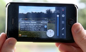
Augmented reality on iPhone (Wikipedia)
Locations and places play in very important role in many eParticipation processes. As a matter of fact eParticipation in urban planning is one of the most successful areas eParticipation to day. In the case of participation processes which are linked to a certain place mobile participation is a very promising trend in general and in this article I would like to take a look at two specific new technologies and what their use in mobile location focussed participation may be: Augmented reality and automated image recognition.
Augmented reality
In a nutshell the term augmented reality describes the enhancement of a live picture provided by camera (mostly on phones) with additional data (commonly gathered from the internet). The data shown is located in space so that the viewer only sees the data he or she is close to. The picture above for example is an example using the Wikitude world browser on the iPhone. Here the live view is enhanced with data from Wikipedia. This kind of technology is available on most location aware smart phones today and is very easy to use.
This video shows this augmented reality app in action:
In an eParticipation process linked to a location this technology can be used in different ways:
- To amend different places in the actual area in discussion with information.
This way participants can for example visit a planning area and directly see all necessary information presented in the actual contexts it is relevant in. - To show and add comments and discussion points directly to the relevant places and objects.
A more advance use would be to allow participants to directly add comments and remarks to actual places in objects and show comments from other participants where they matter. If for example the discussion includes the question whether a set of trees should be cut or not the comments and remarks make much more sense if the location of the trees is attached to them.
This kind of technology use does not exclude participants who would rather use a normal website to get involved. Any comment made in the augmented reality can be displayed in on website either with the location shown on a map or as text information. On the other hand any information enter into a website and amended with geo-data can be used in an augmented reality application.
Overall the augmented reality approach is very promising but the technological hurdles still limit the potential user to a small number. This however might change over the course of 2010 which might be year of location aware devices and software.
Automated image recognition
In late 2009 Google introduced a new service called Google Goggles which allows smart phone users to snap a picture of a landmark, book cover or company logo and get search results based on whatever is shown on the picture. Of course the Goggles is only one implementation of automated image recognition but it shows how fare this technology has developed. The following video explains the tool:
This kind of technology is still in its infant state but I would like to suggest a few ideas how it might be interesting in an eParticipation context:
- It might be used to provide information on places or objects in a specific area. In this case it is similar to the first use of an augmented reality application.
- Discussion about non-stationary or multiple objects. The advantage of this technology is that it can be used on moveable objects which do not have an absolute location as it does not depend on the geo-data but recognizes the object itself. An example would be if a participant takes a picture of a taxi, the system recognizes the object as a taxi and the comment is then recorded as a comment on “taxis”.
Both technologies presented here have potential to enhance eParticipation processes and are signifiers for the two major trends of universal internet access and location awareness. Maybe the suggested uses for eParticipation will not be mainstream any time soon but the overall trends will affect the field in some shape or form very soon.
I for one welcome these possibilities and challenges.
Tags: augmented reality, eParticipation, Google, inenglish, location, wikitude


2 Responses to “Augmented reality and image recognition as tools for eParticipation”
By Dragon on Nov 9, 2010
Don’t forget the privacy problem. I can now use various cellular services to show me points of interest nearby, like shops etc. but as long as the information is gathered and then a complete profile of me is being made (like noticing i always visit a certain place a certain time) i’ll never feel safe using services like these.